Dual Badged Nautical Charts
Dual Badged Nautical Charts
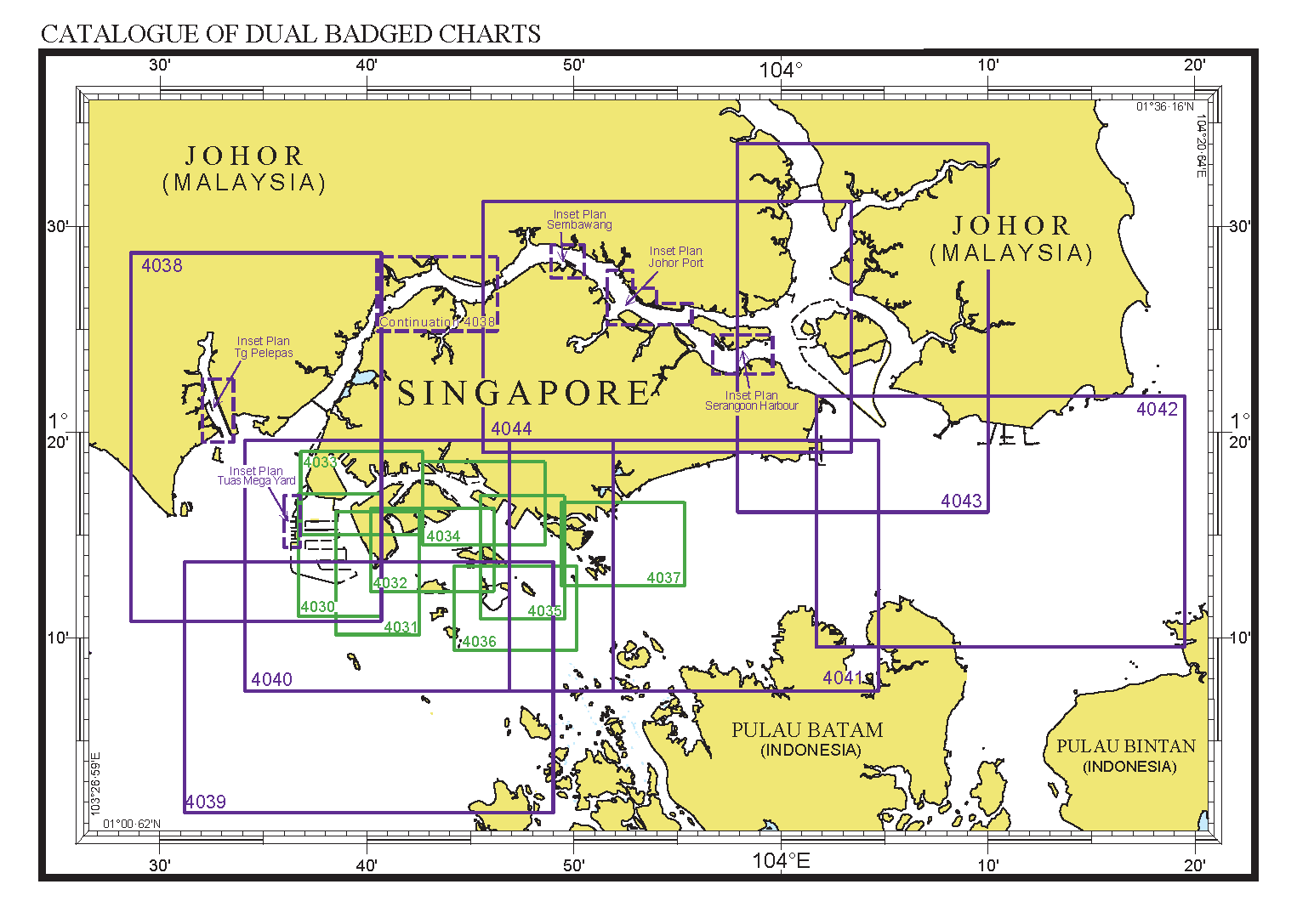
Dual Badged Charts covering Singapore port waters and their approaches.
The Maritime and Port Authority of Singapore (MPA) and the United Kingdom Hydrographic Office (UKHO) have jointly produced a series of nautical charts called the Dual Badged Charts covering Singapore port waters and its approaches.
Based on the World Geodetic System 84 Datum (WGS 84) and conforming to the specifications of the International Hydrographic Organization (IHO) for international charts, there are 15 such jointly produced charts, with new chart editions published once every one or two years.
The list of latest edition Dual Badged Charts can be found in our monthly Singaporean Notices to Mariners. Corrections affecting the Dual Badged Charts will be published in the Admiralty Notices to Mariners and in Section V of the Singapore Notices to Mariners.
List of dual badged charts
| Chart No. | Charts Title and Limit | Scale 1: |
|---|---|---|
| 4030 | Port of Singapore – West Jurong Anchorages and Fairways 1°11.05'N 1°17.00'N 103°36.70'E 103°40.70'E | 10000 |
| 4031 | Port of Singapore – South Jurong Island and its Approaches 1°10.15'N 1°16.12'N 103°38.50'E 103°42.53'E | 10000 |
| 4032 | Port of Singapore – Sinki Fairway 1°12.25'N 1°16.30'N 103°40.20'E 103°46.13'E | 10000 |
| 4033 | Port of Singapore – Tuas Bay, West Jurong Channel and Pesek Basin 1°15.00'N 1°19.05'N 103°36.80'E 103°42.70'E | 10000 |
| 4034 | Port of Singapore – East Jurong Channel, Pasir Panjang Terminal and West Keppel Fairway 1°14.50'N 1°18.55'N 103°42.70'E 103°48.60'E | 10000 |
| 4035 | Port of Singapore – Western Anchorages, Jong Fairway and Cruise Bay 1°10.90'N 1°16.90'N 103°45.50'E 103°49.54'E | 10000 |
| 4036 | Port of Singapore – Raffles Lighthouse to The Sisters 1°09.40'N 1°13.47'N 103°44.20'E 103°50.13'E | 10000 |
| 4037 | Port of Singapore – Keppel Harbour, Tanjong Pagar Terminal and Approaches 1°12.52'N 1°16.59'N 103°49.40'E 103°55.34'E | 10000 |
| 4038 | Johor Strait – Western Part 1°10.80'N 1°28.70'N 103°28.60'E 103°40.70'E | 30000 |
| 4039 | Western Approaches to Main Strait 1°01.50'N 1°13.70'N 103°31.20'E 103°49.00'E | 30000 |
| 4040 | Tuas View to Pulau Sakijang Bendera (St. John's Island) 1°07.40'N 1°19.60'N 103°34.10'E 103°51.90'E | 30000 |
| 4041 | Pulau Sebarok to Changi 1°07.40'N 1°19.60'N 103°46.90'E 104°04.70'E | 30000 |
| 4042 | Changi to Pulau Mungging 1°09.55'N 1°21.75'N 104°01.70'E 104°19.50'E | 30000 |
| 4043 | Kuala Johor and Sungai Johor 1°16.10'N 1°34.00'N 103°57.90'E 104°10.00'E | 30000 |
| 4044 | Johor Strait – Eastern Part 1°19.00'N 1°31.20'N 103°45.60'E 104°03.40'E |
30000 |
These charts can be purchased from the following chart distributors:
E.W. Liner Charts & Publications Pte Ltd
100 Pasir Panjang Road
#05-10
Singapore 118518
Tel: (65) 6323 0773
Fax: (65) 6323 0775
Email: sales@ewliner.com
Website: http://www.ewliner.com
Novaco Navigation Pte Ltd
3791 Jalan Bukit Merah
#05-07 E-Centre @ Redhill
Singapore 159471
Tel: (65) 3163 3253
Email: support@novaco.co.uk
Website: https://novaco.co.uk
Weilbach Singapore Pte Ltd
237 Alexandra Road
#06-18 The Alexcier
Singapore 159929
Tel: (65) 6273 0833
Email: sales@weilbach.com
Website: www.weilbach.com